
Make a donation
Vitória da Conquista topographic map
Click on the map to display elevation.
Make a donation
Vitória da Conquista
The city has a subtropical highland climate (Cfb/Cfa/Cwb/Cwa, according to the Köppen climate classification), relatively dry and moderated in temperature by the elevation. It closely borders a tropical savanna climate (Aw). The altitude of the city itself varies between 857 meters (2811 feet) and 950 meters (3116 feet). Precipitation from April to August is often characterized by fine, misty rain, while heavier rains fall from October to March. Winters (July through October) tend to lack much precipitation but are cool and humid, with cold air coming up to the plateau from the ocean and often producing fog.
Make a donation
About this map
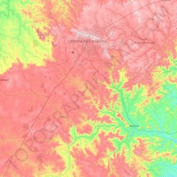
Name: Vitória da Conquista topographic map, elevation, terrain.
Average elevation: 727 m
Minimum elevation: 273 m
Maximum elevation: 1,115 m
Make a donation
Other topographic maps
Click on a map to view its topography, its elevation and its terrain.
Picado
Brazil > Bahia > Região Metropolitana de Feira de Santana > Conceição do Jacuípe
Average elevation: 188 m