
Thank you for supporting this site ❤️
Make a donation
Make a donation
Dawson topographic map
Click on the map to display elevation.
Thank you for supporting this site ❤️
Make a donation
Make a donation
About this map
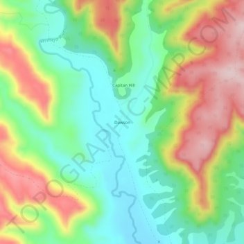
Name: Dawson topographic map, elevation, terrain.
Location: Dawson, Colfax County, New Mexico, United States (36.64420 -104.79472 36.68420 -104.75472)
Average elevation: 2,033 m
Minimum elevation: 1,912 m
Maximum elevation: 2,207 m
Thank you for supporting this site ❤️
Make a donation
Make a donation
Other topographic maps
Click on a map to view its topography, its elevation and its terrain.