
Niederbettingen topographic map
Interactive map
Click on the map to display elevation.
About this map
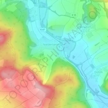
Name: Niederbettingen topographic map, elevation, terrain.
Average elevation: 437 m
Minimum elevation: 377 m
Maximum elevation: 533 m
Other topographic maps
Click on a map to view its topography, its elevation and its terrain.
Bolsdorf
Deutschland > Rheinland-Pfalz > Landkreis Vulkaneifel > Hillesheim > Bolsdorf
Bolsdorf, Hillesheim, Gerolstein, Landkreis Vulkaneifel, Rheinland-Pfalz, 54576, Deutschland
Average elevation: 442 m