
ولسوالی انجیل topographic map
Interactive map
Click on the map to display elevation.
About this map
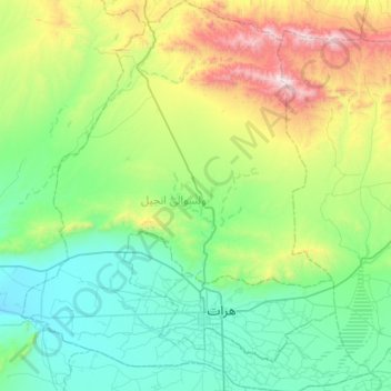
Name: ولسوالی انجیل topographic map, elevation, terrain.
Location: ولسوالی انجیل, Hérât, Afghanistan (34.25324 61.92493 34.72170 62.43217)
Average elevation: 1,259 m
Minimum elevation: 857 m
Maximum elevation: 2,593 m
Other topographic maps
Click on a map to view its topography, its elevation and its terrain.
Silsilah-ye Safēd Kōh
Silsilah-ye Safēd Kōh, چشت شریف, Hérât, Afghanistan
Average elevation: 2,988 m