
Thank you for supporting this site ❤️
Make a donation
Make a donation
Arvilla topographic map
Click on the map to display elevation.
Thank you for supporting this site ❤️
Make a donation
Make a donation
Arvilla
Arvilla (also Orange) is an unincorporated community in central Grand Forks County, North Dakota, United States. It lies along U.S. Route 2, west of the city of Grand Forks, the county seat of Grand Forks County. Its elevation is 1,004 feet (306 m). The community was first named Orange for Orange County, New York; it was renamed Arvilla for Arvilla Estella Hersey, the wife of a local farmer. Although Arvilla is unincorporated, it has a post office, with the ZIP code of 58214.
Thank you for supporting this site ❤️
Make a donation
Make a donation
About this map
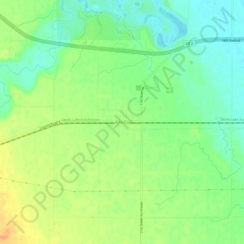
Name: Arvilla topographic map, elevation, terrain.
Average elevation: 308 m
Minimum elevation: 289 m
Maximum elevation: 331 m
Thank you for supporting this site ❤️
Make a donation
Make a donation
Other topographic maps
Click on a map to view its topography, its elevation and its terrain.
Thank you for supporting this site ❤️
Make a donation
Make a donation
Thank you for supporting this site ❤️
Make a donation
Make a donation