
Thank you for supporting this site ❤️
Make a donation
Make a donation
Colony South topographic map
Click on the map to display elevation.
Thank you for supporting this site ❤️
Make a donation
Make a donation
About this map
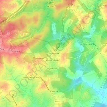
Name: Colony South topographic map, elevation, terrain.
Location: Colony South, Hall County, Georgia, United States (34.20010 -83.84879 34.24010 -83.80879)
Average elevation: 328 m
Minimum elevation: 276 m
Maximum elevation: 380 m
Thank you for supporting this site ❤️
Make a donation
Make a donation
Other topographic maps
Click on a map to view its topography, its elevation and its terrain.
Thank you for supporting this site ❤️
Make a donation
Make a donation
Sterling on the Lake Dam #1
United States > Georgia > Hall County > Flowery Branch
Average elevation: 299 m
Thank you for supporting this site ❤️
Make a donation
Make a donation