
Vandalur topographic map
Interactive map
Click on the map to display elevation.
About this map
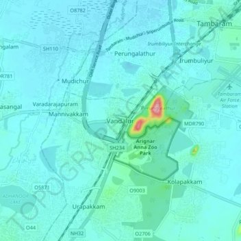
Name: Vandalur topographic map, elevation, terrain.
Average elevation: 27 m
Minimum elevation: 13 m
Maximum elevation: 160 m
Vandalur hill is part of Arignar Anna Zoological Park and public entry to the hill is restricted. The hilltop provides a good view of the OMR and Mannivakam. The Tamil Nadu Forest department has a sapling center under the foothill of Vandalur hill. The run has a total ascent of 274.99 ft and has a maximum elevation of 484.97 ft.
Other topographic maps
Click on a map to view its topography, its elevation and its terrain.
Maraimalai Nagar
India > Tamil Nadu > Chengalpattu
Maraimalai Nagar, Chengalpattu, Chengalpattu District, Tamil Nadu, 603209, India
Average elevation: 49 m