
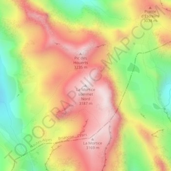
La Mortice sommet Nord topographic map
Interactive map
Click on the map to display elevation.
About this map
Name: La Mortice sommet Nord topographic map, elevation, terrain.
Average elevation: 2,851 m
Minimum elevation: 2,469 m
Maximum elevation: 3,175 m
Other topographic maps
Click on a map to view its topography, its elevation and its terrain.
Bois de la Pinée
France > Provence-Alpes-Côte d'Azur > Vars
Bois de la Pinée, Chemin des Escreins, Rebrun, Vars, Briançon, Hautes-Alpes, Provence-Alpes-Côte d'Azur, France métropolitaine, 05560, France
Average elevation: 2,130 m
Béal des Turins
France > Provence-Alpes-Côte d'Azur > Vars
Béal des Turins, Vars, Briançon, Hautes-Alpes, Provence-Alpes-Côte d'Azur, France métropolitaine, 05560, France
Average elevation: 1,985 m