
Le Champelet Derrière topographic map
Interactive map
Click on the map to display elevation.
About this map
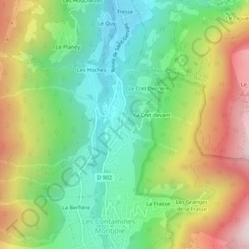
Name: Le Champelet Derrière topographic map, elevation, terrain.
Average elevation: 1,321 m
Minimum elevation: 1,010 m
Maximum elevation: 1,808 m
Other topographic maps
Click on a map to view its topography, its elevation and its terrain.
Le Champelet Devant
France > Auvergne-Rhône-Alpes > Haute-Savoie > Les Contamines-Montjoie > La Cret devant
Le Champelet Devant, La Cret devant, Les Contamines-Montjoie, Bonneville, Haute-Savoie, Auvergne-Rhône-Alpes, France métropolitaine, 74170, France
Average elevation: 1,334 m