
Thank you for supporting this site ❤️
Make a donation
Make a donation
Hohkeppel topographic map
Click on the map to display elevation.
Thank you for supporting this site ❤️
Make a donation
Make a donation
Hohkeppel
Das Kirchdorf Hohkeppel ist ein Ortsteil der Gemeinde Lindlar im Oberbergischen Kreis in Nordrhein-Westfalen. Es liegt etwa sieben Kilometer südwestlich von Lindlar, südlich von Schmitzhöhe.
Thank you for supporting this site ❤️
Make a donation
Make a donation
About this map
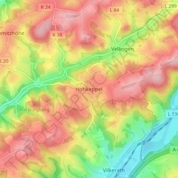
Name: Hohkeppel topographic map, elevation, terrain.
Average elevation: 195 m
Minimum elevation: 99 m
Maximum elevation: 272 m
Thank you for supporting this site ❤️
Make a donation
Make a donation
Other topographic maps
Click on a map to view its topography, its elevation and its terrain.
51789
Deutschland > Nordrhein-Westfalen > Oberbergischer Kreis > Lindlar > Süttenbach
Average elevation: 237 m