
Thank you for supporting this site ❤️
Make a donation
Make a donation
Rattu topographic map
Click on the map to display elevation.
Thank you for supporting this site ❤️
Make a donation
Make a donation
About this map
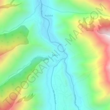
Name: Rattu topographic map, elevation, terrain.
Location: Rattu, Astore District, Gilgit-Baltistan, Pakistan (35.13168 74.77348 35.17168 74.81348)
Average elevation: 2,949 m
Minimum elevation: 2,564 m
Maximum elevation: 3,781 m
Thank you for supporting this site ❤️
Make a donation
Make a donation
Other topographic maps
Click on a map to view its topography, its elevation and its terrain.