
Thank you for supporting this site ❤️
Make a donation
Make a donation
Puerto Viejo topographic map
Click on the map to display elevation.
Thank you for supporting this site ❤️
Make a donation
Make a donation
About this map
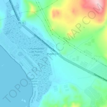
Name: Puerto Viejo topographic map, elevation, terrain.
Location: Puerto Viejo, San Antonio, Cañete, Lima, Perú (-12.59141 -76.71614 -12.55141 -76.67614)
Average elevation: 56 m
Minimum elevation: -1 m
Maximum elevation: 280 m
Thank you for supporting this site ❤️
Make a donation
Make a donation
Other topographic maps
Click on a map to view its topography, its elevation and its terrain.