
Make a donation
Urbino topographic map
Click on the map to display elevation.
Make a donation
Urbino
The century began quietly. In addition to the artistic development from the Scuola del Libro, Urbino also began to grow as a university town, with the elevation to university faculty of nineteenth-century School of Pharmacy and the birth of the department of Education (approximately 1934). Due to these changes in the University, an increase in the student population led to housing shortages that highlighted the state of total unpreparedness of the city, so much that for the first time many students were housed in the homes of private citizens. The problem was partly solved with the establishment of the male boarding school "Raphael" at the beginning of the century, and the female boarding school "Laura Battiferri" in approximately 1926.
Make a donation
About this map
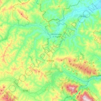
Name: Urbino topographic map, elevation, terrain.
Location: Urbino, Pesaro e Urbino, Marche, 61029, Italy (43.66130 12.43501 43.84021 12.77380)
Average elevation: 301 m
Minimum elevation: 30 m
Maximum elevation: 968 m
Make a donation
Other topographic maps
Click on a map to view its topography, its elevation and its terrain.