
Hohnstorf (Elbe) topographic map
Interactive map
Click on the map to display elevation.
About this map
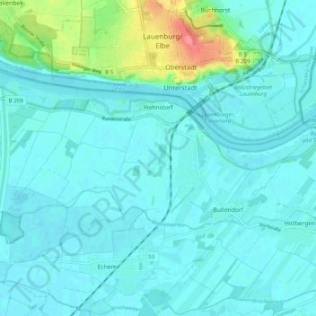
Name: Hohnstorf (Elbe) topographic map, elevation, terrain.
Average elevation: 12 m
Minimum elevation: 2 m
Maximum elevation: 69 m
Other topographic maps
Click on a map to view its topography, its elevation and its terrain.
Artlenburg
Allemagne > Basse-Saxe > Lunebourg (arrondissement)
Artlenburg, Samtgemeinde Scharnebeck, Lunebourg (arrondissement), Basse-Saxe, 21380, Allemagne
Average elevation: 12 m
Scharnebeck
Allemagne > Basse-Saxe > Lunebourg (arrondissement)
Scharnebeck, Samtgemeinde Scharnebeck, Lunebourg (arrondissement), Basse-Saxe, Allemagne
Average elevation: 22 m
Graben 11 (Artlenburg)
Allemagne > Basse-Saxe > Lunebourg (arrondissement) > Artlenburg
Graben 11 (Artlenburg), Artlenburg, Samtgemeinde Scharnebeck, Lunebourg (arrondissement), Basse-Saxe, 21380, Allemagne
Average elevation: 6 m
Graben 6
Allemagne > Basse-Saxe > Lunebourg (arrondissement) > Bleckede > Garlstorf
Graben 6, Garlstorf, Bleckede, Lunebourg (arrondissement), Basse-Saxe, 21354, Allemagne
Average elevation: 9 m