
MacArthur topographic map
Interactive map
Click on the map to display elevation.
About this map
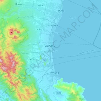
Name: MacArthur topographic map, elevation, terrain.
Average elevation: 110 m
Minimum elevation: -2 m
Maximum elevation: 1,122 m
Other topographic maps
Click on a map to view its topography, its elevation and its terrain.
Santa Rosa
菲律宾 / 菲律賓 > Leyte > Tabango > Kawayan > Santa Rosa
Santa Rosa, Kawayan, Tabango, Leyte 3rd District, Leyte, Eastern Visayas, 6536, 菲律宾 / 菲律賓
Average elevation: 23 m