
Cornella topographic map
Interactive map
Click on the map to display elevation.
About this map
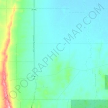
Name: Cornella topographic map, elevation, terrain.
Location: Cornella, Shire of Campaspe, Victoria, Australia (-36.72476 144.71002 -36.64895 144.82184)
Average elevation: 163 m
Minimum elevation: 122 m
Maximum elevation: 341 m
Other topographic maps
Click on a map to view its topography, its elevation and its terrain.
Balfe Park
Australia > Victoria > Melbourne
Balfe Park, Brunswick East, Melbourne, City of Merri-bek, Victoria, Australia
Average elevation: 43 m
Macedon District
Australia > Victoria > Riddells Creek
Macedon District, Old Orchard Court, Riddells Creek, Shire of Macedon Ranges, Loddon Mallee, Victoria, 3431, Australia
Average elevation: 430 m