
Paulusmühle topographic map
Interactive map
Click on the map to display elevation.
About this map
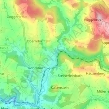
Name: Paulusmühle topographic map, elevation, terrain.
Average elevation: 470 m
Minimum elevation: 377 m
Maximum elevation: 624 m
Other topographic maps
Click on a map to view its topography, its elevation and its terrain.
Ernsting
Deutschland > Bayern > Landkreis Freyung-Grafenau > Steinerleinbach
Ernsting, Steinerleinbach, Röhrnbach, Landkreis Freyung-Grafenau, Bayern, 94133, Deutschland
Average elevation: 472 m