
Make a donation
Megamendung topographic map
Click on the map to display elevation.
Make a donation
About this map
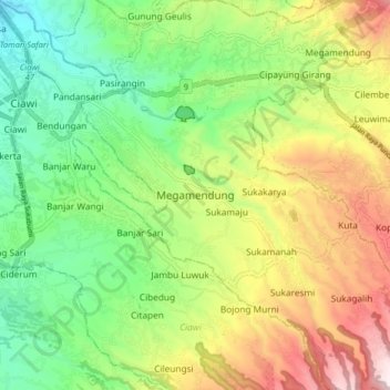
Name: Megamendung topographic map, elevation, terrain.
Location: Megamendung, Bogor, West Java, Java, 16770, Indonesia (-6.71465 106.84294 -6.63465 106.92294)
Average elevation: 627 m
Minimum elevation: 363 m
Maximum elevation: 1,026 m
Make a donation
Other topographic maps
Click on a map to view its topography, its elevation and its terrain.
Make a donation
Make a donation
Make a donation
Make a donation
Make a donation
Make a donation
Make a donation
Make a donation
Make a donation
Megamendung
Much of the district lies in an elevation of 500-600 metres, which moderates the temperature, and causing contrast to the heat of Greater Jakarta and other adjacent low-lying lands. Though much of the built-up area is not necessarily on rugged terrain, uneven ground is the most common terrain as it stands…
Average elevation: 742 m
Make a donation
Make a donation
Make a donation
Make a donation
Cisarua
Cisarua is a location and district in the Bogor Regency, located in the province of West Java, with a population of 127,096 in 2020. The district is known for its mild climate, tea fields, and extensive views, being located in a rather high altitude.
Average elevation: 1,310 m
Make a donation