Betws-y-Coed topographic map
Interactive map
Click on the map to display elevation.
About this map
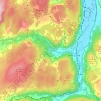
Name: Betws-y-Coed topographic map, elevation, terrain.
Average elevation: 187 m
Minimum elevation: 7 m
Maximum elevation: 390 m

Click on the map to display elevation.
Name: Betws-y-Coed topographic map, elevation, terrain.
Average elevation: 187 m
Minimum elevation: 7 m
Maximum elevation: 390 m