
Thank you for supporting this site ❤️
Make a donation
Make a donation
Südharz topographic map
Click on the map to display elevation.
Thank you for supporting this site ❤️
Make a donation
Make a donation
About this map
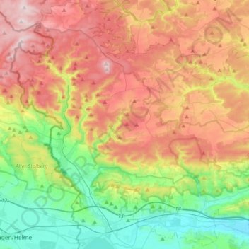
Name: Südharz topographic map, elevation, terrain.
Location: Südharz, Mansfeld-Südharz, Saxony-Anhalt, 06536, Germany (51.43968 10.88277 51.63379 11.20019)
Average elevation: 341 m
Minimum elevation: 136 m
Maximum elevation: 600 m
Thank you for supporting this site ❤️
Make a donation
Make a donation
Other topographic maps
Click on a map to view its topography, its elevation and its terrain.