
Thank you for supporting this site ❤️
Make a donation
Make a donation
Kurna topographic map
Click on the map to display elevation.
Thank you for supporting this site ❤️
Make a donation
Make a donation
About this map
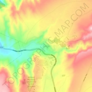
Name: Kurna topographic map, elevation, terrain.
Location: Kurna, Burdur Merkez, Burdur, Mediterranean Region, Turkey (37.68017 30.32538 37.72017 30.36538)
Average elevation: 1,198 m
Minimum elevation: 1,054 m
Maximum elevation: 1,306 m
Thank you for supporting this site ❤️
Make a donation
Make a donation
Other topographic maps
Click on a map to view its topography, its elevation and its terrain.