
Thank you for supporting this site ❤️
Make a donation
Make a donation
Rockton topographic map
Click on the map to display elevation.
Thank you for supporting this site ❤️
Make a donation
Make a donation
About this map
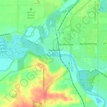
Name: Rockton topographic map, elevation, terrain.
Average elevation: 235 m
Minimum elevation: 216 m
Maximum elevation: 270 m
Thank you for supporting this site ❤️
Make a donation
Make a donation
Other topographic maps
Click on a map to view its topography, its elevation and its terrain.
Thank you for supporting this site ❤️
Make a donation
Make a donation
Samuelson Corners
United States > Illinois > Winnebago County > Rockford > Samuelson Corners
Average elevation: 253 m
Thank you for supporting this site ❤️
Make a donation
Make a donation