
Ferrol topographic map
Interactive map
Click on the map to display elevation.
About this map
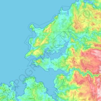
Name: Ferrol topographic map, elevation, terrain.
Location: Ferrol, A Corogne, Galice, 15402, Espagne (43.32469 -8.39316 43.64469 -8.07316)
Average elevation: 98 m
Minimum elevation: -4 m
Maximum elevation: 575 m
Other topographic maps
Click on a map to view its topography, its elevation and its terrain.
San Román de Doniños
Espagne > Galice > Ferrol > Ferrol
San Román de Doniños, Doniños, Ferrol, A Corogne, Galice, 15593, Espagne
Average elevation: 143 m
San Felipe
Espagne > Galice > Ferrol > Ferrol > San Felipe
San Felipe, Brión, Ferrol, A Corogne, Galice, 15591, Espagne
Average elevation: 92 m