
Thank you for supporting this site ❤️
Make a donation
Make a donation
Thiruthiparambu topographic map
Click on the map to display elevation.
Thank you for supporting this site ❤️
Make a donation
Make a donation
About this map
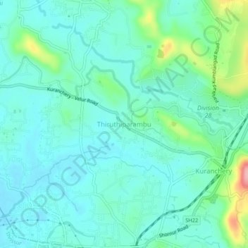
Name: Thiruthiparambu topographic map, elevation, terrain.
Location: Thiruthiparambu, Talappilly, Thrissur, Kerala, 680623, India (10.61821 76.19161 10.65821 76.23161)
Average elevation: 36 m
Minimum elevation: 6 m
Maximum elevation: 153 m
Thank you for supporting this site ❤️
Make a donation
Make a donation
Other topographic maps
Click on a map to view its topography, its elevation and its terrain.
Sreekumar,Kalathil Veedu, Kumbalangad Vaka Kulam 2
India > Kerala > Talappilly
Average elevation: 39 m
Thank you for supporting this site ❤️
Make a donation
Make a donation
Thank you for supporting this site ❤️
Make a donation
Make a donation