
Make a donation
Whitehouse topographic map
Click on the map to display elevation.
Make a donation
About this map
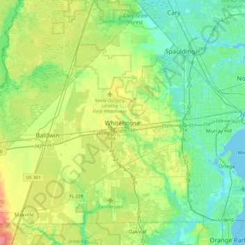
Name: Whitehouse topographic map, elevation, terrain.
Average elevation: 19 m
Minimum elevation: -2 m
Maximum elevation: 60 m
Make a donation
Other topographic maps
Click on a map to view its topography, its elevation and its terrain.
Jacksonville
United States > Florida > Duval County
Just south of Jacksonville and north of Saint Augustine is the boundary of where the Floridian Peninsula ends and Continental North America begins; Jacksonville is north of that line. While still in the North American Coastal plain, the topography begins to take on slight Piedmont characteristics. Like the…
Average elevation: 10 m
Jacksonville
United States > Florida > Duval County
Jacksonville features a predominantly flat topography with an average elevation of approximately 16 feet (5 meters) above sea level. This coastal city is characterized by its extensive riverine systems, particularly the St. Johns River, which meanders through the landscape, contributing to a rich ecosystem of…
Average elevation: 10 m
The Lil' Saint John's River
United States > Florida > Duval County > Jacksonville Beach
Average elevation: 3 m
Make a donation
Julington-Durbin Preserve
United States > Florida > Duval County > Jacksonville
Average elevation: 7 m
L C Ringhaver Park
United States > Florida > Duval County > Jacksonville > Venetia Terrace
Average elevation: 5 m
Make a donation
Jacksonville
United States > Florida > Duval County
Just south of Jacksonville and north of Saint Augustine is the boundary of where the Floridian Peninsula ends and Continental North America begins; Jacksonville is north of that line. While still in the North American Coastal plain, the topography begins to take on slight Piedmont characteristics. Like the…
Average elevation: 10 m
Make a donation
The Lil' Saint John's River
United States > Florida > Duval County > Jacksonville Beach
Average elevation: 3 m
Dutton Island Preserve
United States > Florida > Duval County > Jacksonville > Oak Harbor
Average elevation: 2 m
Make a donation
Make a donation
Make a donation