
Make a donation
Charlestown topographic map
Click on the map to display elevation.
Make a donation
About this map
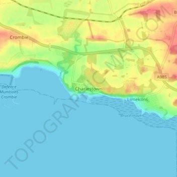
Name: Charlestown topographic map, elevation, terrain.
Location: Charlestown, Fife, Scotland, KY11 3ED, United Kingdom (56.01683 -3.52027 56.05683 -3.48027)
Average elevation: 19 m
Minimum elevation: 0 m
Maximum elevation: 65 m
Make a donation
Other topographic maps
Click on a map to view its topography, its elevation and its terrain.
Make a donation
Make a donation
Kellie Castle
United Kingdom > Scotland > Fife > Arncroach > Newton of Balcormo
Average elevation: 69 m
Make a donation
Make a donation
Make a donation
Make a donation
Inverkeithing
United Kingdom > Scotland > Fife
Topographically, Inverkeithing is situated on a raised terrace sloping down towards Inverkeithing Bay, which cuts in to the south of the town, separating it from the North Queensferry peninsula. Its medieval centre lay along High Street and Church Street, but the town has since expanded to encompass areas to…
Average elevation: 28 m
Make a donation