
Thank you for supporting this site ❤️
Make a donation
Make a donation
Chrishall topographic map
Click on the map to display elevation.
Thank you for supporting this site ❤️
Make a donation
Make a donation
About this map
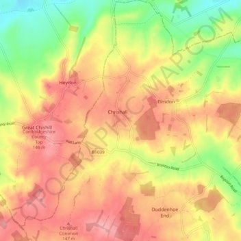
Name: Chrishall topographic map, elevation, terrain.
Location: Chrishall, Uttlesford, Essex, England, United Kingdom (52.00227 0.07766 52.06059 0.12830)
Average elevation: 110 m
Minimum elevation: 48 m
Maximum elevation: 153 m
Thank you for supporting this site ❤️
Make a donation
Make a donation
Other topographic maps
Click on a map to view its topography, its elevation and its terrain.