
Thank you for supporting this site ❤️
Make a donation
Make a donation
Gamaliel topographic map
Click on the map to display elevation.
Thank you for supporting this site ❤️
Make a donation
Make a donation
About this map
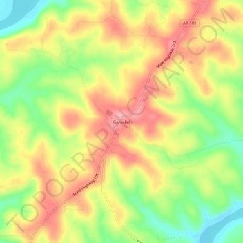
Name: Gamaliel topographic map, elevation, terrain.
Location: Gamaliel, Baxter County, Arkansas, 72537, United States (36.43673 -92.25321 36.47673 -92.21321)
Average elevation: 229 m
Minimum elevation: 164 m
Maximum elevation: 284 m
Thank you for supporting this site ❤️
Make a donation
Make a donation
Other topographic maps
Click on a map to view its topography, its elevation and its terrain.
Thank you for supporting this site ❤️
Make a donation
Make a donation
Thank you for supporting this site ❤️
Make a donation
Make a donation
Thank you for supporting this site ❤️
Make a donation
Make a donation