
Thank you for supporting this site ❤️
Make a donation
Make a donation
McNary topographic map
Click on the map to display elevation.
Thank you for supporting this site ❤️
Make a donation
Make a donation
McNary
At an elevation of 7,316 feet (2,230 m), it is the second highest community in Arizona after Alpine.
Thank you for supporting this site ❤️
Make a donation
Make a donation
About this map
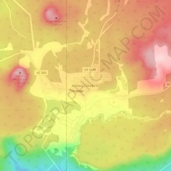
Name: McNary topographic map, elevation, terrain.
Location: McNary, Apache County, Arizona, 85930, United States (34.05470 -109.87375 34.09470 -109.83375)
Average elevation: 2,228 m
Minimum elevation: 2,080 m
Maximum elevation: 2,321 m
Thank you for supporting this site ❤️
Make a donation
Make a donation
Other topographic maps
Click on a map to view its topography, its elevation and its terrain.
Thank you for supporting this site ❤️
Make a donation
Make a donation
Thank you for supporting this site ❤️
Make a donation
Make a donation
Window Rock
United States > Arizona > Apache County
Window Rock is categorized as being within the 6a USDA hardiness zone, meaning the average annual extreme minimum temperature is between −10 and −5 °F (−23 and −21 °C). The city is cooler than most of Arizona due to its high elevation.
Average elevation: 2,084 m
Thank you for supporting this site ❤️
Make a donation
Make a donation