
Mamer topographic map
Interactive map
Click on the map to display elevation.
About this map
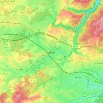
Name: Mamer topographic map, elevation, terrain.
Location: Mamer, Canton Capellen, Luxembourg (49.59891 5.95874 49.65575 6.06062)
Average elevation: 315 m
Minimum elevation: 260 m
Maximum elevation: 378 m
Sa superficie est de 2 752 ha et son point culminant se trouve au lieu-dit Juckelbösch à une altitude de 353 m.
Other topographic maps
Click on a map to view its topography, its elevation and its terrain.
Bascharage
Luxembourg > Canton Capellen > Käerjeng
Bascharage, Käerjeng, Canton Capellen, 4955, Luxembourg
Average elevation: 313 m
Eischen
Luxembourg > Canton Capellen > Habscht
Eischen, Habscht, Canton Capellen, Luxembourg
Average elevation: 339 m
Capellen
Luxembourg > Canton Capellen > Mamer
Capellen, Mamer, Canton Capellen, Luxembourg
Average elevation: 316 m
Dahlem
Luxembourg > Canton Capellen > Dahlem
Dahlem, Garnich, Canton Capellen, 8351, Luxembourg
Average elevation: 349 m
Schouweiler
Luxembourg > Canton Capellen > Schouweiler
Schouweiler, Dippach, Canton Capellen, 4999, Luxembourg
Average elevation: 341 m