
Thank you for supporting this site ❤️
Make a donation
Make a donation
Luttenberg topographic map
Click on the map to display elevation.
Thank you for supporting this site ❤️
Make a donation
Make a donation
About this map
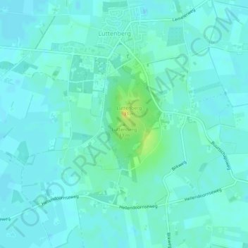
Name: Luttenberg topographic map, elevation, terrain.
Location: Luttenberg, Raalte, Overijssel, Nederland, 8105 TZ, Nederland (52.39644 6.36716 52.39654 6.36726)
Average elevation: 10 m
Minimum elevation: 5 m
Maximum elevation: 28 m
Thank you for supporting this site ❤️
Make a donation
Make a donation