
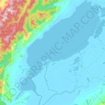
Lake Wairarapa topographic map
Interactive map
Click on the map to display elevation.
About this map
Name: Lake Wairarapa topographic map, elevation, terrain.
Average elevation: 106 m
Minimum elevation: -4 m
Maximum elevation: 819 m
Other topographic maps
Click on a map to view its topography, its elevation and its terrain.
Lower Hutt
Nouvelle-Zélande > Wellington > Lower Hutt City
Lower Hutt, Lower Hutt City, Wellington, 5040, Nouvelle-Zélande
Average elevation: 173 m
1390
Nouvelle-Zélande > Wellington > Carterton District
1390, Carterton District, Wellington, Nouvelle-Zélande
Average elevation: 1,062 m
Whakapapa
Nouvelle-Zélande > Wellington > Masterton District
Whakapapa, Masterton District, Wellington, Nouvelle-Zélande
Average elevation: 429 m
Wellington
Nouvelle-Zélande > Wellington > Wellington City
Wellington, Wellington City, Wellington, 6011, Nouvelle-Zélande
Average elevation: 85 m
Lower Hutt City
Nouvelle-Zélande > Wellington > Lower Hutt City
Lower Hutt City, Wellington, Nouvelle-Zélande
Average elevation: 164 m
Deraa
Deraa, South Wairarapa District, Wellington, Nouvelle-Zélande
Average elevation: 408 m
Greytown
Nouvelle-Zélande > Wellington > Greytown
Greytown, South Wairarapa District, Wellington, 5712, Nouvelle-Zélande
Average elevation: 59 m