
Inopacan topographic map
Interactive map
Click on the map to display elevation.
About this map
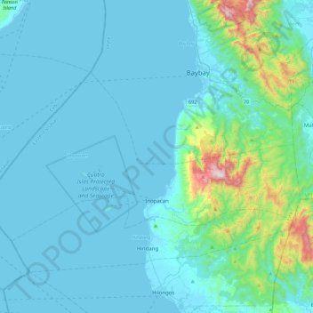
Name: Inopacan topographic map, elevation, terrain.
Average elevation: 113 m
Minimum elevation: 0 m
Maximum elevation: 1,121 m
Other topographic maps
Click on a map to view its topography, its elevation and its terrain.
Mailhi
Philippines > Leyte > Baybay
Mailhi, Baybay, 5th District, Leyte, Eastern Visayas, 6521, Philippines
Average elevation: 236 m
Kabalasan
Philippines > Leyte > Baybay
Kabalasan, Baybay, 5th District, Leyte, Eastern Visayas, Philippines
Average elevation: 44 m
Albuera
Albuera, 4th District, Leyte, Eastern Visayas, 6542, Philippines
Average elevation: 147 m
Manlawaan
Philippines > Leyte > Leyte
Manlawaan, Leyte, 3rd District, Leyte, Eastern Visayas, 6533, Philippines
Average elevation: 79 m
Pangasugan
Philippines > Leyte > Baybay
Pangasugan, Baybay, Leyte 5th District, Leyte, Eastern Visayas, 6521, Philippines
Average elevation: 61 m
Patag
Philippines > Leyte > Baybay
Patag, Baybay, Leyte 5th District, Leyte, Eastern Visayas, 6521, Philippines
Average elevation: 64 m
San Augustin
Philippines > Leyte > Babatngon
San Augustin, Babatngon, Leyte, Eastern Visayas, 6520, Philippines
Average elevation: 10 m
Babatngon
Babatngon, Leyte, Eastern Visayas, 6520, Philippines
Average elevation: 36 m
Bulak
Philippines > Leyte > Abuyog > Bulak
Bulak, Abuyog, Leyte 5th District, Leyte, Eastern Visayas, 6510, Philippines
Average elevation: 80 m
Hilaan
Philippines > Leyte > Hilongos
Hilaan, Hilongos, Leyte 5th District, Leyte, Eastern Visayas, 6524, Philippines
Average elevation: 243 m
Odiongan
Philippines > Leyte > Abuyog
Odiongan, Abuyog, Leyte 5th District, Leyte, Eastern Visayas, 6510, Philippines
Average elevation: 15 m
Baybay
Baybay, Leyte 5th District, Leyte, Eastern Visayas, 6521, Philippines
Average elevation: 157 m
Langit
Philippines > Leyte > Alangalang
Langit, Alangalang, Leyte 1st District, Leyte, Eastern Visayas, 6517, Philippines
Average elevation: 16 m
Tacloban
Philippines > Leyte > Tacloban
Tacloban, Leyte, Eastern Visayas, 6500, Philippines
Average elevation: 29 m
Mount Aminduen
Philippines > Leyte > Jaro
Mount Aminduen, Jaro, Leyte 2nd District, Leyte, Eastern Visayas, 6527, Philippines
Average elevation: 814 m
Carigara
Carigara, Leyte 2nd District, Leyte, Eastern Visayas, 6529, Philippines
Average elevation: 134 m
Mount Sacripante
Philippines > Leyte > Inopacan
Mount Sacripante, Inopacan, Leyte 5th District, Leyte, Eastern Visayas, 6522, Philippines
Average elevation: 760 m
Calubian
Calubian, Leyte 3rd District, Leyte, Eastern Visayas, 6534, Philippines
Average elevation: 148 m
MacArthur
MacArthur, Leyte 2nd District, Leyte, Eastern Visayas, 6509, Philippines
Average elevation: 110 m
Sea of Clouds
Philippines > Leyte > Baybay > Cuatro de Agosto
Sea of Clouds, Tacloban-Baybay Road, Crossing, Cuatro de Agosto, Baybay, Leyte 5th District, Leyte, Eastern Visayas, 6512, Philippines
Average elevation: 187 m
Kalipayan
Philippines > Leyte > Burauen > Kalipayan
Kalipayan, Burauen, Leyte 2nd District, Leyte, Eastern Visayas, 6506, Philippines
Average elevation: 57 m
Jaro
Philippines > Leyte > Jaro
Jaro, Leyte 2nd District, Leyte, Eastern Visayas, 6527, Philippines
Average elevation: 210 m
Lake Bito
Philippines > Leyte > Javier > Inayupan
Lake Bito, Inayupan, Javier, Leyte 5th District, Leyte, Eastern Visayas, 6511, Philippines
Average elevation: 20 m
Ormoc
Ormoc, Leyte 4th District, Leyte, Eastern Visayas, 6541, Philippines
Average elevation: 210 m
Javier
Philippines > Leyte > Javier
Javier, Leyte 5th District, Leyte, Eastern Visayas, 6511, Philippines
Average elevation: 170 m
Busay
Philippines > Leyte > Barugo > Busay
Busay, Barugo, Leyte 2nd District, Leyte, Eastern Visayas, 6519, Philippines
Average elevation: 18 m
Jubay
Philippines > Leyte > Calubian > Jubay
Jubay, Calubian, Leyte 3rd District, Leyte, Eastern Visayas, Philippines
Average elevation: 21 m
Taglawigan
Philippines > Leyte > San Isidro > Taglawigan
Taglawigan, San Isidro, Leyte 3rd District, Leyte, Eastern Visayas, Philippines
Average elevation: 37 m
Calaguise
Philippines > Leyte > Leyte > Calaguise
Calaguise, Leyte, Leyte 3rd District, Leyte, Eastern Visayas, 6533, Philippines
Average elevation: 23 m
Divisoria
Philippines > Leyte > Alangalang > Divisoria
Divisoria, Alangalang, Leyte 1st District, Leyte, Eastern Visayas, 6517, Philippines
Average elevation: 50 m
San Francisco East
Philippines > Leyte > Alangalang > San Francisco East
San Francisco East, Alangalang, Leyte 1st District, Leyte, Eastern Visayas, 6517, Philippines
Average elevation: 27 m
San Miguel
Philippines > Leyte > Dulag > San Miguel
San Miguel, Dulag, Leyte 2nd District, Leyte, Eastern Visayas, 6505, Philippines
Average elevation: 3 m
Tanauan
Philippines > Leyte > Tanauan
Tanauan, Leyte 1st District, Leyte, Eastern Visayas, 6502, Philippines
Average elevation: 7 m
Capoocan
Philippines > Leyte > Capoocan
Capoocan, Leyte 2nd District, Leyte, Eastern Visayas, 6530, Philippines
Average elevation: 71 m
Isabel
Isabel, 4th District, Leyte, Eastern Visayas, 6539, Philippines
Average elevation: 39 m
Caibaan
Philippines > Leyte > Tacloban > Caibaan
Caibaan, Tacloban, Leyte, Eastern Visayas, 6500, Philippines
Average elevation: 43 m
Tunga
Tunga, Leyte 2nd District, Leyte, Eastern Visayas, 6528, Philippines
Average elevation: 62 m
Barrio Polahungon
Philippines > Leyte > Barrio Polahungon
Barrio Polahungon, Mahaplag, Leyte 5th District, Leyte, Eastern Visayas, 6512, Philippines
Average elevation: 136 m
Dayhagan
Philippines > Leyte > Dayhagan
Dayhagan, Ormoc, Leyte 4th District, Leyte, Eastern Visayas, 6541, Philippines
Average elevation: 94 m
Merida
Philippines > Leyte > Merida
Merida, Leyte 4th District, Leyte, Eastern Visayas, 6540, Philippines
Average elevation: 42 m
Ormoc
Philippines > Leyte > Ormoc
Ormoc, Leyte 4th District, Leyte, Eastern Visayas, 6541, Philippines
Average elevation: 201 m