
Thank you for supporting this site ❤️
Make a donation
Make a donation
Vineyard topographic map
Click on the map to display elevation.
Thank you for supporting this site ❤️
Make a donation
Make a donation
About this map
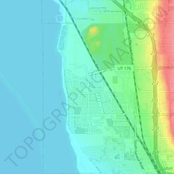
Name: Vineyard topographic map, elevation, terrain.
Location: Vineyard, Utah County, Utah, 84059, United States (40.27835 -111.77242 40.33345 -111.73237)
Average elevation: 1,382 m
Minimum elevation: 1,366 m
Maximum elevation: 1,447 m
Thank you for supporting this site ❤️
Make a donation
Make a donation
Other topographic maps
Click on a map to view its topography, its elevation and its terrain.
Thank you for supporting this site ❤️
Make a donation
Make a donation
Thank you for supporting this site ❤️
Make a donation
Make a donation
Thank you for supporting this site ❤️
Make a donation
Make a donation