Make a donation
Basel topographic map
Click on the map to display elevation.
Make a donation
Basel
Of the built up area, industrial buildings made up 10.2% of the total area while housing and buildings made up 40.7% and transportation infrastructure made up 24.0%. Power and water infrastructure as well as other special developed areas made up 2.7% of the area while parks, green belts and sports fields made up 8.9%. Out of the forested land, all of the forested land area is covered with heavy forests. Of the agricultural land, 2.5% is used for growing crops and 1.3% is pastures. All the water in the municipality is flowing water. The topography of the region is notably flat, as Basel is situated in a valley basin. The Rhine, one of Europe's largest and most significant rivers, flows directly through the heart of the city, dividing it into Grossbasel on the left bank and Kleinbasel on the right.
Make a donation
About this map
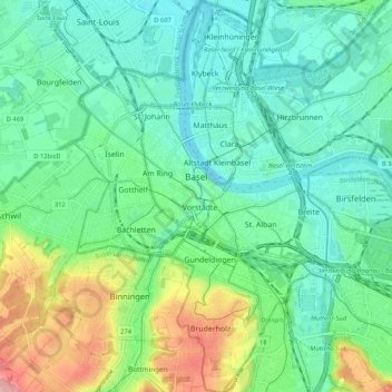
Name: Basel topographic map, elevation, terrain.
Location: Basel, Basel-City, Switzerland (47.51929 7.55466 47.58990 7.63414)
Average elevation: 285 m
Minimum elevation: 243 m
Maximum elevation: 396 m
Make a donation
Other topographic maps
Click on a map to view its topography, its elevation and its terrain.