
Thank you for supporting this site ❤️
Make a donation
Make a donation
Masvingo Province topographic map
Click on the map to display elevation.
Thank you for supporting this site ❤️
Make a donation
Make a donation
About this map
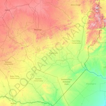
Name: Masvingo Province topographic map, elevation, terrain.
Location: Masvingo Province, Zimbabwe (-22.42411 29.73450 -19.15076 32.40560)
Average elevation: 700 m
Minimum elevation: 82 m
Maximum elevation: 2,267 m
Thank you for supporting this site ❤️
Make a donation
Make a donation
Other topographic maps
Click on a map to view its topography, its elevation and its terrain.
Marondera
Zimbabwe > Mashonaland East Province > Marondera
Marondera is situated on the highveld plateau, and has a subtropical highland climate (Köppen Cwb). The city enjoys a sunny climate, with the summer months (October to April) characterised by warm to hot days followed by afternoon thundershowers and cool evenings, and the winter months (May to September) by…
Average elevation: 1,637 m