
Town of Smithtown topographic map
Interactive map
Click on the map to display elevation.
About this map
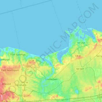
Name: Town of Smithtown topographic map, elevation, terrain.
Location: Town of Smithtown, Suffolk County, New York, United States (40.80383 -73.31907 41.03649 -73.12142)
Average elevation: 21 m
Minimum elevation: -2 m
Maximum elevation: 107 m
Other topographic maps
Click on a map to view its topography, its elevation and its terrain.
Shelter Island
United States > New York > Suffolk County
Shelter Island, Town of Shelter Island, Suffolk County, New York, United States
Average elevation: 4 m