
La Baissière topographic map
Interactive map
Click on the map to display elevation.
About this map
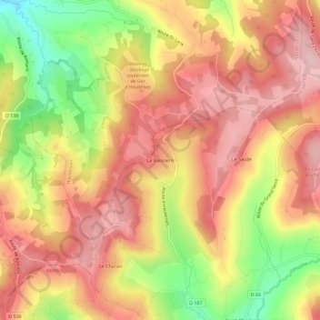
Name: La Baissière topographic map, elevation, terrain.
Average elevation: 430 m
Minimum elevation: 303 m
Maximum elevation: 511 m
Other topographic maps
Click on a map to view its topography, its elevation and its terrain.
Le Sauze
France > Auvergne-Rhône-Alpes > Drôme > Saint-Christophe-et-le-Laris
Le Sauze, Saint-Christophe-et-le-Laris, Valence, Drôme, Auvergne-Rhône-Alpes, France métropolitaine, 26350, France
Average elevation: 443 m
Saint-Christophe
France > Auvergne-Rhône-Alpes > Drôme > Saint-Christophe-et-le-Laris > Saint-Christophe
Saint-Christophe, Saint-Christophe-et-le-Laris, Valence, Drôme, Auvergne-Rhône-Alpes, France métropolitaine, 26350, France
Average elevation: 408 m