
Make a donation
Coatepec topographic map
Click on the map to display elevation.
Make a donation
Coatepec
The municipality of Coatepec (Spanish: [koateˈpek] ) is located in the central region of the Mexican state of Veracruz. Its north latitude is 19° 27′, west longitude is 96° 58′, altitude of 1,200.00 m (3,937.01 ft), and surface of 202.4 km2 (78.1 sq mi), which represents 0.338% of the current state. The municipal seat and largest community of the municipality is also called Coatepec. The Mexican census of 2020 reported a population of 55,720 in the city, while the municipality had 93,911 inhabitants. The municipality also includes many smaller communities within its boundaries. The largest of these are Tuzamapan (population 8,300) Pacho Viejo (4,829), and Mahuixtlán (3,946).
Make a donation
About this map
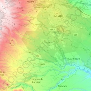
Name: Coatepec topographic map, elevation, terrain.
Location: Coatepec, Veracruz, Mexico (19.35727 -97.10623 19.53239 -96.79703)
Average elevation: 1,404 m
Minimum elevation: 424 m
Maximum elevation: 3,143 m
Make a donation
Other topographic maps
Click on a map to view its topography, its elevation and its terrain.
Make a donation
Make a donation
Fraccionamiento Santa Regina
Mexico > Veracruz > Poza Rica de Hidalgo > Poza Rica
Average elevation: 71 m
Cofre de Perote
Cofre de Perote, also known by its Nahuatl names Naupa-Tecutépetl (from Nāuhpa-Tēuctēpetl) and Nauhcampatépetl, both meaning something like "Place of Four Mountains" or "Mountain of the Lord of Four Places", is an inactive volcano located in the Mexican state of Veracruz, at the point where the…
Average elevation: 3,817 m
Make a donation
Make a donation
Make a donation
Isthmus of Tehuantepec
At its narrowest point, the isthmus is 200 km (124 mi) across from gulf to gulf, or 192 km (119 mi) to the head of Laguna Superior on the Pacific coast. The Sierra Madre del Sur mountain range breaks down at this point into a broad, plateau-like ridge, whose elevation, at the highest point reached by the…
Average elevation: 277 m
Make a donation
Make a donation
Make a donation
Fraccionamiento Costa Dorada
Mexico > Veracruz > Veracruz > Colonia del Proletariado (Pica Pica) > Fraccionamiento Costa Dorada
Average elevation: 26 m
Make a donation