
Athens topographic map
Interactive map
Click on the map to display elevation.
About this map
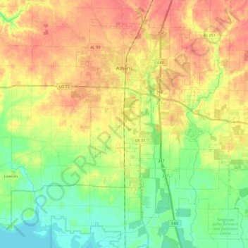
Name: Athens topographic map, elevation, terrain.
Location: Athens, Limestone County, Alabama, 35611, United States (34.68571 -87.08573 34.84086 -86.86372)
Average elevation: 204 m
Minimum elevation: 166 m
Maximum elevation: 248 m
Other topographic maps
Click on a map to view its topography, its elevation and its terrain.
Wheeler Lake
United States > Alabama > Limestone County > Mooresville
Wheeler Lake, Mooresville, Limestone County, Alabama, United States
Average elevation: 220 m
Holland Gin
United States > Alabama > Limestone County
Holland Gin, Limestone County, Alabama, United States
Average elevation: 273 m
Tanner
United States > Alabama > Limestone County
Tanner, Limestone County, Alabama, United States
Average elevation: 199 m
Elkmont
United States > Alabama > Limestone County
Elkmont, Limestone County, Alabama, 35620, United States
Average elevation: 249 m
Irvington
United States > Alabama > Limestone County > Decatur > Irvington
Irvington, Decatur, Limestone County, Alabama, 35671, United States
Average elevation: 178 m
Athens
United States > Alabama > Limestone County > Athens
Athens, Limestone County, Alabama, United States
Average elevation: 205 m