
Thank you for supporting this site ❤️
Make a donation
Make a donation
Rodgau topographic map
Click on the map to display elevation.
Thank you for supporting this site ❤️
Make a donation
Make a donation
About this map
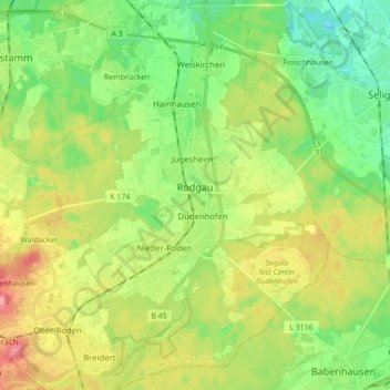
Name: Rodgau topographic map, elevation, terrain.
Location: Rodgau, Landkreis Offenbach, Гессен, 63110, Германия (49.95934 8.81881 50.07111 8.94463)
Average elevation: 132 m
Minimum elevation: 100 m
Maximum elevation: 179 m
Thank you for supporting this site ❤️
Make a donation
Make a donation
Other topographic maps
Click on a map to view its topography, its elevation and its terrain.
FFH-Gebiet Sendefunkstelle Mainflingen/Zellhausen
Германия > Гессен > Landkreis Offenbach > Mainflingen
Average elevation: 114 m