
Thank you for supporting this site ❤️
Make a donation
Make a donation
Hoher Trailing topographic map
Click on the map to display elevation.
Thank you for supporting this site ❤️
Make a donation
Make a donation
About this map
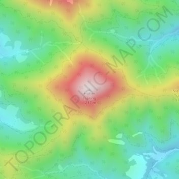
Name: Hoher Trailing topographic map, elevation, terrain.
Average elevation: 774 m
Minimum elevation: 525 m
Maximum elevation: 1,205 m
Thank you for supporting this site ❤️
Make a donation
Make a donation
Other topographic maps
Click on a map to view its topography, its elevation and its terrain.
Natuschutzgebiet Jaidhaus
Österreich > Oberösterreich > Bezirk Kirchdorf > Molln
Average elevation: 685 m