
Thank you for supporting this site ❤️
Make a donation
Make a donation
Sandayong topographic map
Click on the map to display elevation.
Thank you for supporting this site ❤️
Make a donation
Make a donation
About this map
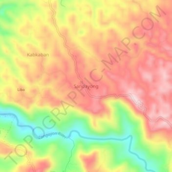
Name: Sandayong topographic map, elevation, terrain.
Location: Sandayong, Cebu, Central Visayas, Philippines (10.68129 123.85210 10.72129 123.89210)
Average elevation: 208 m
Minimum elevation: 24 m
Maximum elevation: 341 m
Thank you for supporting this site ❤️
Make a donation
Make a donation
Other topographic maps
Click on a map to view its topography, its elevation and its terrain.