
Thank you for supporting this site ❤️
Make a donation
Make a donation
Tilleda (Kyffhäuser) topographic map
Click on the map to display elevation.
Thank you for supporting this site ❤️
Make a donation
Make a donation
Tilleda (Kyffhäuser)
Tilleda liegt in der Goldenen Aue, direkt am Nordrand des Kyffhäusergebirges. Durch den Ort fließt der aus dem Kyffhäusergebirge kommende Wolweda Bach, Hauptzufluss zur Kleinen Helme (Gewässerzahl 5647.6). Nördlich des Ortes befinden sich inmitten der Goldenen Aue die kleineren Höhen der Sittendorfer bzw. Brückener Heide, welche die Goldene Aue in einen oberen und unteren Teil trennen.
Thank you for supporting this site ❤️
Make a donation
Make a donation
About this map
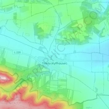
Name: Tilleda (Kyffhäuser) topographic map, elevation, terrain.
Average elevation: 211 m
Minimum elevation: 143 m
Maximum elevation: 438 m
Thank you for supporting this site ❤️
Make a donation
Make a donation
Other topographic maps
Click on a map to view its topography, its elevation and its terrain.
Sittendorf
Deutschland > Sachsen-Anhalt > Mansfeld-Südharz > Kelbra (Kyffhäuser)
Average elevation: 203 m