
New York topographic map
Interactive map
Click on the map to display elevation.
About this map
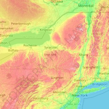
Name: New York topographic map, elevation, terrain.
Location: New York, États-Unis (40.47740 -79.76194 45.01586 -71.79557)
Average elevation: 278 m
Minimum elevation: -1 m
Maximum elevation: 1,417 m
La superficie totale de la ville de New York est de 1 214 km2, dont 785 km2 de terres émergées et 429 km2 d’eau. L'altitude maximale est de 124,9 m au-dessus du niveau de la mer, sur Todt Hill à Staten Island.
Other topographic maps
Click on a map to view its topography, its elevation and its terrain.
Adirondack
États-Unis > New York > Adirondack
Adirondack, Town of Horicon, Warren County, New York, 12808, États-Unis
Average elevation: 294 m
Malone
États-Unis > New York > Malone
Malone, Franklin County, New York, 12953, États-Unis
Average elevation: 231 m
Torrey
Torrey, Yates County, New York, 14441, États-Unis
Average elevation: 201 m
Washington County
Kingsbury, Washington County, New York, 12839, États-Unis
Average elevation: 77 m