
Make a donation
Calabanga topographic map
Click on the map to display elevation.
Make a donation
Calabanga
The topographic landscape of the municipality could be characterized as generally flat with a slope 0-3%, gently sloping (3-8%) towards the direction of the eastern portion and finally rolling up to higher steeps towards the direction of the south-eastern part going to Mt. Isarog. The 0-3% slope is a broad area of flat to nearly level land which extends from Barangay Balongay along the Bicol River to Poblacion area and surrounding areas down to Barangay Manguiring. This is the dominant slope of the municipality.
Make a donation
About this map
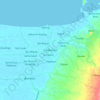
Name: Calabanga topographic map, elevation, terrain.
Location: Calabanga, Camarines Sur, Bicol Region, 4405, Philippines (13.66855 123.17576 13.74855 123.25576)
Average elevation: 11 m
Minimum elevation: -1 m
Maximum elevation: 79 m
Make a donation
Other topographic maps
Click on a map to view its topography, its elevation and its terrain.
Nabua
Nabua has about 8,803.0600 hectares or 99.42% very low elevation or less than 100 meters elevation and remaining 51.3593 hectares or 0.58% of low elevation or between 100 and 300 meters elevation. Its slope covers about 7,927.3616 hectares or 89.53% which are level to nearly level (0-3%) while the remaining…
Average elevation: 27 m
Make a donation