
Thank you for supporting this site ❤️
Make a donation
Make a donation
Jammalamadugu topographic map
Click on the map to display elevation.
Thank you for supporting this site ❤️
Make a donation
Make a donation
Jammalamadugu
Jammalamadugu is at 14°50′N 78°24′E / 14.83°N 78.4°E / 14.83; 78.4. It has an average elevation of 169 metres (554 feet).
Thank you for supporting this site ❤️
Make a donation
Make a donation
About this map
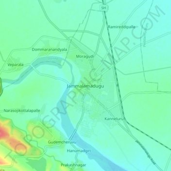
Name: Jammalamadugu topographic map, elevation, terrain.
Location: Jammalamadugu, YSR district, Andhra Pradesh, 516434, India (14.80735 78.34217 14.88735 78.42217)
Average elevation: 184 m
Minimum elevation: 172 m
Maximum elevation: 232 m
Thank you for supporting this site ❤️
Make a donation
Make a donation