
Crawley topographic map
Interactive map
Click on the map to display elevation.
About this map
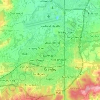
Name: Crawley topographic map, elevation, terrain.
Location: Crawley, West Sussex, Engeland, Verenigd Koninkrijk (51.08481 -0.25563 51.16730 -0.13298)
Average elevation: 80 m
Minimum elevation: 39 m
Maximum elevation: 165 m
Other topographic maps
Click on a map to view its topography, its elevation and its terrain.
Earnley
Verenigd Koninkrijk > Engeland > West Sussex > Chichester
Earnley, Chichester, West Sussex, Engeland, Verenigd Koninkrijk
Average elevation: 2 m