
Thank you for supporting this site ❤️
Make a donation
Make a donation
Minley topographic map
Click on the map to display elevation.
Thank you for supporting this site ❤️
Make a donation
Make a donation
About this map
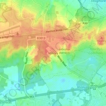
Name: Minley topographic map, elevation, terrain.
Location: Minley, Hart, Hampshire, England, GU17 9JT, United Kingdom (51.29546 -0.83911 51.33546 -0.79911)
Average elevation: 79 m
Minimum elevation: 59 m
Maximum elevation: 107 m
Thank you for supporting this site ❤️
Make a donation
Make a donation
Other topographic maps
Click on a map to view its topography, its elevation and its terrain.
Thank you for supporting this site ❤️
Make a donation
Make a donation
Thank you for supporting this site ❤️
Make a donation
Make a donation
Thank you for supporting this site ❤️
Make a donation
Make a donation
Crookham Village
United Kingdom > England > Hampshire > Hart > Crookham Village
Average elevation: 81 m
Thank you for supporting this site ❤️
Make a donation
Make a donation