
Thank you for supporting this site ❤️
Make a donation
Make a donation
Cady topographic map
Click on the map to display elevation.
Thank you for supporting this site ❤️
Make a donation
Make a donation
About this map
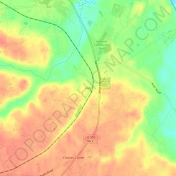
Name: Cady topographic map, elevation, terrain.
Location: Cady, Hanover County, Virginia, 23069, United States (37.72264 -77.38192 37.76264 -77.34192)
Average elevation: 41 m
Minimum elevation: 8 m
Maximum elevation: 63 m
Thank you for supporting this site ❤️
Make a donation
Make a donation
Other topographic maps
Click on a map to view its topography, its elevation and its terrain.